|
Aug
10 , 1983 Wednesday (573.1 mtg) From
Gonzo!s Appalachian Trail journal
Woke
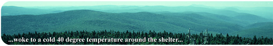
up to a cold 40 degree temperature around the shelter. Two and
a half miles past the shelter, at Harmon Hill, the trail began to
drop down to Route 9 and began the major ascent that would last
the majority of the day. Passing Nauhiem Shelter along the way,
the trail took me up Maple Hill and several other unnamed peaks
on it's way to Glastonberry Mountain, an elevation change of about
2500 feet. The change sounds like a lot, but actually happens over
roughly ten miles of trail. This does not mean that it was a piece
of cake, there were areas where the climb was more severe, such
as the initial climb out from route 9. I enjoyed the view from the
old firetower on top of Glastonberry Mountain, and the wonderful
weather that I was treated to that day. The cold front that had
chilled me last night made for bright, crisp non-hazy skies. Glastonberry
was covered in Spruce and Balsam Fir trees and the smell of Christmas
filled the air. I could see for miles over the Green Mountains of
Vermont and back into Massachusetts, where I had just come from.
Four miles of descent from Glastonberry brought me to the first
of two shelters situated within one-quarter mile of each other.
The Kid Gore Shelter was very nice and I had intended to stay the
night there until a group of YMCA boys showed up. I then decided
to move on to Caughnawaga Shelter where I hoped there were a few
less bodies. Seems as though I am running into more outing groups
the farther up the trail I go. Water supplies in Vermont seem to
be a lot better than those in Massachusetts and just south of there.
The temperature in the evenings seemed to be more on the cool side
as well. Probably due to the higher altitude.
Gonzo!
Appalachian Trail Journals ©1983
|