|
Aug
20 , 1983 Saturday (396.7 mtg) From
Gonzo!s Appalachian Trail journal
Not
sunny at all this morning. As a matter of fact, it was foggy. Hopefully
the fog was only resting in the valley waiting for the sun to burn
it off. Today I officially enter the White Mountains, the land that
hikers hear about on the trip north as being tough, but really worth
it. From the look of the profile, I am sure it will be tough. The
climb is almost five miles and involves a change in elevation of
almost four thousand feet! Sounded like the toughest climb yet!
The trail followed a road for a while just past the shelter, and
the map indicated a state sanitarium just a little farther up the
road. Probably populated by hikers who lost their minds after attempting
such a climb. I turned from the road into the woods and the climb
began. There were water flows everywhere on the trail and I tried
to go up as fast as I could in my usual manner, but soon learned
that that is not the way things are done in the Whites. I learned
that I had to go more slowly if I wanted to make the ascent in one
shot without breaks. No switchbacks, just up, up, up. The trail
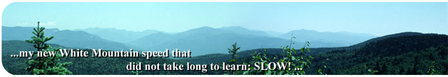
also made use of large rocks as "steps." My new White
Mountain speed that did not take long to learn: SLOW!
The trail began to become even more rocky and vegetation became
more of the scrub variety. Low growing evergreen type trees. The
smell of the holidays was back. About a mile from the summit, the
trail joined the Old Carriage Trail coming in from the right that
years ago, near the turn of the century, was used to transport vacationers
to the Summit House on top of Mount Moosilauke. With the size of
the boulders sunk in the trail, I could only imagine how bumpy that
horse drawn carriage ride must have been.
As I neared the summit I broke out of the scrub growth and entered
the "above treeline" section. At this point the combination
of weather, altitude and latitude produce a situation where no trees
are able to survive, and what grasses and other small plants do
survive there do so precariously. Stepping off the trail can possibly
kill a plant, therefore it is recommended that hikers stay on the
trail to minimize damage and prevent erosion. Above treeline there
was nothing but fog. I could only see a few feet in front of me
as I watched for white blazes painted on the rocks under my feet
and occasionally some on the larger boulders. The guide book mentions
that there are ruins of the summit house on the summit, and goes
on to say "from the summit the trail descends…."
I found the ruins of some building, but not at the highest point.
Of course I could not really see the highest point and so I looked
for blazes descending from that point. I found none. I followed
what few white blazes I could see and finally located a small weatherworn
sign that indicated .1 miles to what turned out to be the actual
summit. Near the summit the wind and fog were severe, with moisture
condensing upon the lenses of my glasses, not helping the visibility
any. I decided I had better get down to a "safer" altitude.
I had my rainjacket over my wool sweater to keep me warm, but my
legs were exposed. I could tell there were trails leaving the summit,
but the markings were so poor that I could not tell which one was
the A.T. - if any were. I backtracked back to the summit house.
I found no trails leaving from there, so back to the summit I went.
I picked one of the trails from the summit and began the descent.
I went down following rock cairns and just about got blown off the
mountain by a strong blast of wind along an open area. I found no
white blazes after a ¼ to ½ mile, so to keep from
getting lost I backtracked to the summit once more through the blowing
wind and drizzle. I frantically got out the guide and read it again.
I chose another trail and did the same again. Still not the right
trail. I was beginning to become somewhat scared, I did not want
to go back the way I came. I needed to find the trail to the north
and move on. My next attempt was the last trail that I could have
chosen and I eventually found my familiar white blaze, very faint,
off in the fog. I headed down the mountain and quickly ducked into
the shelter provided by the low scrub growth several hundred feet
farther down the side of the mountain. The descent was not so bad
for about a mile and a half, and then, well - all I can say is that
it was practically straight down, at least it was some of the steepest
trail I had encountered yet.
I passed several "tourons," a name given to those other
than thru-hikers in the Whites, on the way down the steep, quite
vertical section. I had difficulty scrambling down some of the sections
over slanting rock slabs. The combination of the steepness and the
water flowing all around, together with the mud between the rocks,
made the conditions less than desirable.
Just before Kinsman Notch, I took a break at Beaver Brook Shelter
Lean-to where I thought about staying, but decided to push on. Today
was Saturday, and the shelter was too close to the road for comfort.
Besides, I had only gone just under ten miles - even though they
were some of the toughest hiking that I had ever done.
On
the way out of Kinsman Notch I passed some boy scouts, and then
two girls from New York. The skies began to clear as I made my way
toward the summit of Wolf Mountain and eventually I did get treated
to some "views." There was a section of new trail near
a major powerline intersecting the trail just before Eliza Brook
Shelter. At the shelter I finally caught up with John
Smart and his dog Smokie. Another hiker, Irv
Warfield "The Trail Walker" was in residence too,
but both had just finishing their breaks and tried to convince me
to move ahead to the Kinsman Pond Shelter. I declined, even though
I had now caught up with John, a friend from way down south and
two years ago. Fourteen point seven miles for the day as an introduction
to the Whites was enough for me! Just past the shelter began another
steep climb up Kinsman Mountain. I would save that for tomorrow.
The two hikers left, but soon after the two girls from New York
arrived and decided to spend the night. The boy scouts also made
their home by the stream. I tuned my radio in to the Saturday night
program on PBS, which included "A Prairie Home Companion",
and introduced the girls to the show that I always tried to pick
up on Saturday nights. Listening to Garrison Keillor weave his stories
about Lake Wobegon while high in the New Hampshire Mountains made
the evening special. The clouds pulled back and left a bright moon
flooding the landscape with light. Maybe tomorrow the sky would
be clear and provide some of those great White Mountain views.
One of the girls carried a Sierra cup. I saw potential in having
one of them, so I convinced her to lend it to me tomorrow after
she made the distance to Liberty Springs Campsite, where I planned
on spending the night.
Gonzo!
Appalachian Trail Journals ©1983
|