|
Aug
24 , 1983 Wednesday (346.1 mtg) From
Gonzo!s Appalachian Trail journal
This
morning Mr. Hardy drove me back to the trailhead in Crawford Notch,
where I had left off the night before. The road through Crawford
notch ran beside the Saco River, which had to be crossed before
beginning the ascent of Webster Cliffs, the beginning of a section
of the White Mountains known as the Presidential Range. This area
is noted for its amazing views, tough hiking, and bad weather. The
climb out of the Notch had an elevation gain of 1500 feet in just
one mile! Most of the climbing up to this point usually covered
no more than 1000 feet in a mile. By the third mile into the day's
hike I was passing over Webster Cliffs on my way toward Mt Webster.
The cliffs provided breathtaking views down into Crawford Notch
and across the notch to the mountains from which I had come. I stopped
many times to photograph and take in the scenery. Scenery like this
is what the trip is all about.
I began to approach the summit of Mt Webster even though I stopped
repeatedly at the views provided by the Webster Cliffs just before
the summit. Upon reaching the summit, I began the gradual ascent
along the ridge that would ultimately culminate on the summit of
Mt Washington after passing over or around many peaks, all named
after presidents of the United States. Only Clingmans Dome in the
Smoky Mountains surpasses Mt Washington in elevation. From Mt Webster
I traveled just over a mile and stepped onto the top of Mt Jackson.
Each stop along the way seemed to provide a view more impressive
than the one before. I could see the rocky cone of Mt. Washington
projecting above all the rest on this beautiful morning.
One and a half miles beyond Mt Jackson, I stopped at Mizpah Hut,
the place I had scheduled to stay tonight, but rescheduled last
night after going somewhat farther than I had anticipated. There
were few people at the place, but eventually I located one of the
hut crew and was able to obtain a weather forecast. The prediction
seemed quite agreeable - highs in the 50's with 2 mile per hour
winds, clear and sunny. Can't get much better than this, especially
in the Presidential Range.
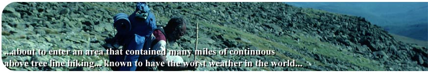
Not far beyond the hut, I came across a sign that informed me that
I was about to enter an area that contained many miles of continuous
above treeline hiking, and that this particular area was known
to have the worst weather in the world. What! Today seemed so
nice. But apparently the weather could change very rapidly since
at least three weather patterns converge near Mt. Washington causing
wildly fluctuating weather patterns. I continued on, happy with
the weather that I was experiencing as I gradually stepped out of
the scrub growth onto the "barren" rocky above treeline
trail. I had only four more miles to get to Lake of the Clouds Hut,
where I had reservations to spend the night. At the summit of Mount
Pierce (4310'), the trail begins a 12.7 mile section of trail that
is almost entirely above tree line, with little protection from
wind and rain. Mt. Pierce is also known as Mt Clinton, and this
name is used more, even though Pierce is the official name. The
trail had been following the Webster Cliffs Trail up to this point.
Just beyond, it becomes part of the Crawford Path all the way to
Mt. Washington.
As the trail approaches Mt. Eisenhower, a loop trail continues to
the summit, while the A.T. skirts the summit on its eastern side.
My path, the A.T., lead me through some scrub growth. I will have
to go to the summit on some other trip. Mt. Eisenhower had been
named Mt. Pleasant until 1972 when the name was changed to honor
the past president.
I passed just west of the summit of Mt. Franklin, and then past
Mt. Monroe. The trail bypassed their summits as well. If I had not
been so dead set on doing the "whole" trail without deviating,
I could have had even more views today. As it was, the views into
the Dry River Wilderness to the East, and toward Mt. Washington
were some of the best I had seen on the entire trip, so I was satisfied
at the time.
Coming around the east side of Monroe, the outline of Lake of the
Clouds Hut came into view and there was still plenty of daylight
and good weather to be had. I checked into the hut, but asked if
there was work to be had that I might stay the night for free, but
was told there was nothing to do. I asked one of the hutboys if
there was a daypack that I could borrow for the afternoon as I made
the hut my basecamp and set out to explore. Thinking that the weather
could change by tomorrow, I decided to climb up the remaining mile
and a half to the summit of Mt. Washington and get the view during
this magnificent stroke of luck that I had received with the weather.
I practically ran up the remaining trail having no weight to hold
me back besides a camera, water bottle and some snacks. The freedom
of no pack was like a freedom from my ball and chain. The entire
route was just one big rock hop. One rock to the next, there is
virtually no soil but what remains in obscure areas with delicate
vegetation hanging on for dear life.
At the summit there are many buildings, too many as far as I was
concerned. This was no longer a wilderness experience, people could
actually drive up an auto road to the 6228' summit, or take a cog
trail if they chose to. There was a weather station, The Tip Top
House (an old Victorian resort from days gone by), and a new visitors
center with cafeteria, museum, and its own small post office. I
stopped at the post office to see if my package had arrived. It
had, but I would pick it up tomorrow. No sense in carrying everything
down and then back up tomorrow morning. Of course, while in the
civilization at the top of the mountain, I called mom and talked
for ten minutes (cost $6.15). What a hoot! arriving at the top of
the highest peak in New Hampshire and being able to make a phone
call! I reported where I was and told her that according to my counting,
this was the 101st day on the trail! (It was actually the 102nd
day) And a beautiful day it was for an area known for having "The
worst weather in the world". The temperature was 47 degrees
fahrenheit, with only two mile per hour winds! Clear as a bell,
allowing me to see for miles and miles. They say that you can see
the Atlantic Ocean from Mt. Washington, but it is so far away, I
would not know it even if I saw it. Three days to Gorham, the next
maildrop. Mom informed me that the old boots were sewn up and resoled
- ready whenever I needed them. (note
from Mom)
I left the summit, this time heading south, back towards Lake of
the Clouds Hut, where I would spend the night in the dungeon since
they said they did not have work for me. I had gone down probably
about half way when the next hiker I saw, I immediately recognized
as Winston
Lumsdon "The Great Appalachian Trail Athelete, the southbound
black thru-hiker. There was no mistaking him, first off he was black.
As far as I knew, the only black thru-hiker on the trail. I knew
he was a thru-hiker just by the way he looked. It does not take
long out on the trail to develop an eye to distinguish a regular
hiker from a thru-hiker. As a matter of fact, the eyes are not the
only organ that can detect a thru-hiker. The nose is quite reliable
as well. I introduced myself and immediately became charmed by this
anomaly. Winston was an older man, retired professor he said, from
Tuskeegee University. He claimed to be a pilot from the Tuskeegee
Air Base, and although I think he was telling the truth, you kind
of wondered how exaggerated it really was. He carried a couple of
old plastic milk jugs tied to his pack that functioned as his water
bottles, although at the time I don't think they were filled. I
would hope they were not filled - the weight would have been tremendous.
They jostled around as he hiked, making an interesting sound, and
I found them to be a curious aspect that set him apart from other
hikers. He and I hiked back to the hut together and talked along
the way.
Back at the hut, Winston talked with the hut crew and somehow with
his charm talked them into giving him the leftover pancakes from
breakfast. He was such a conman that he even convinced them to warm
them up for him! What a guy. After that he started working on lodging.
He had his routine down, and in no time had convinced them into
letting him spend the night in exchange for kitchen cleanup duty.
I immediately asked if I could get in on this deal as well, and
this time was accepted. I was in the presence of a professional.
We helped the crew prepare some of the food, but our job mostly
was with cleanup. When the meal was over and the dishes began to
be brought back for washing, Winston announced "I is the Goreman"
in a thick black dialect as he scraped the uneaten food from the
plates into the garbage. I washed the dishes as he completed his
"gore" duty. We had a blast.
Later that night one of the hut boys set up a large telescope outside
where the stars numbered into the billions as the sky remained clear.
The moon was bright and may have been a full moon as he set up the
device to look at the craters. I had my first view ever of Saturn
as it quickly passed from the center of the view piece to the edge
and the out of view. We looked at Globular Clusters as well. All
would disappear from view just as fast due to the earths' rotation.
Jupiter came and went as well. Todays' visibility was estimated
at 90 miles. 10.5 miles to Lake of the Clouds Hut, but almost 14
with the side trip up Washington and back. The day could not have
been nicer.
Gonzo!
Appalachian Trail Journals ©1983
|