|
Sept
18 , 1983 Sunday (7.2 mtg) From
Gonzo!s Appalachian Trail journal
Rich
and I decided that if at all possible we would climb today - views
or no views. If there were no views we could always climb again
the next day. But climb today to finish.
We set off toward Katahdin Stream Campground following moose tracks
in the moist trail as if the moose were going the same place that
we were. We covered the two miles, partly on park road, to the ranger
station very quickly, accelerated by our excitement to begin the
ascent. At the rangers station we signed in and indicated our destination
as Baxter Peak, shed our packs from our backs, and loaded our day
packs. I had carried a day pack that was sent to me in Monson, while
Rich borrowed one that had been left at the ranger's station. The
ranger informed us that the day was categorized as a Class II day.
He told us that it had snowed up on the summit last night, but had
probably melted. Class two was better than I had expected, Class
I being the ultimate day. The way the weather looked yesterday I
expected worse. We noticed two other hikers had signed in before
us, not necessarily thru-hikers.
The climb began. We reached Katahdin Stream Falls within a mile,
stopped for a few photos, and were off again. I quickly outdistanced
The Rock Hopper, and found myself alone during the final ascent.
Being alone was sort of fitting, it had been a personal journey,
and although I had begun as a member of a two-person team, the finish
was all mine, the biggest thing that I had ever set out to do -
and now seemed to be successful at accomplishing.
The climb steepened. Climbing 2000 feet in the next mile and a half
through a succession of birch trees that slowly changed into evergreen
forest whose trees gradually became shorter until I emerged from
treeline and could only see clouds before me - no summit. About
a mile of regular rock scrambling similar to that in the White Mountains
began. As I made my way up the slope, the windward side of the ridge
seemed to clear, while the clouds seemed to be materializing from
the sharp edge of the ridge on the opposite side. Perhaps when I
reached the top there would be no clouds.
One
mile beyond, I reached an area known as "The Gateway."
The going got a little tricky at this point. The boulders became
much larger, and in order to follow the trail, iron handholds imbedded
into the rocks had to be utilized to pull myself up and over the
jumble of boulders. This area soon gave way to the "Tableland,"
a more level section, as the name implies, before the final mile
of the trail, the ascent to Baxter Peak and the end of the Appalachian
Trail. On the Tableland I could see no more than 15 yards into the
thick cloud cover that hung in the air, and my hopes of having a
view began to dwindle.
Suddenly a small hole appeared in the clouds before me and I saw
a peak that I thought might be my destination. As quickly as it
appeared, it disappeared, and the sky was full of grey again. The
appearance of a hole in the blanket of gray provided some hope that
I might get some views if I waited long enough. I knew I was getting
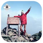
close. Minutes later, I could just barely make out the summit marker
as it grew more visible with every step that I took. The marker,
weatherworn from exposure to the elements, became more visible as
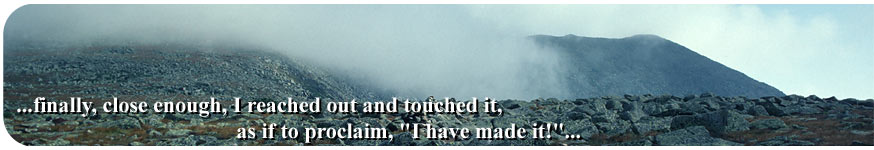
I approached. Finally, close enough, I reached out and touched
it as if to proclaim "I have made it!" I had hiked
the 2138 mile long Appalachian Trail! - "All In One Roll!"
- End to end in one season!
I was
at the top, by myself, in the fog.
The
wind was strong, and the clouds continued to roll by. I got out
a candy bar, nibbled on the sweetness, and began to wait for a clearing
in the sky. I must have really blasted out in front of everyone
that morning, as I sat on the summit by myself for almost forty-five
minutes to an hour and still I was the only one there. I felt a
sense of accomplishment, yet not as elated as one would expect.
A lifestyle that I had grown to love, and a feeling of freedom that
came along with it was about to come to an end. I had done something
many people just dream about, yet now that I faced the reality of
becoming a regular member of society, the thought of having done
the trail becomes a dream, a dream that was real, yet now in the
past.
I was
at the top, by myself, in a fog.
After
about forty-five minutes, the clouds miraculously began to dissipate
and an opening appeared. Immense! What Grandeur! The view was breathtaking!
The view back toward the Tableland, and in the other direction….the
Knife Edge! The sharp dropoff was produced by glacial action during
the ice age. With the help of the self timer on my camera, I took
pictures of myself while sitting near the sign indicating Springer
Mountain to be 2100 miles south. I made a toast to myself with my
congratulatory A & W Rootbeer that I had carried 110 miles from
Monson, Maine specifically for the occasion.
Suddenly other hikers began to arrive from many different trails.
I asked one of them to take a photo with my camera of me standing
proudly in victory at the summit. Later, Rich
arrived, then mobs from other trails. I found it rather strange,
but the first thing that they all did upon arriving was to stake
out a spot and begin eating, just as I had. Butch and Rob eventually
showed up with their one pack between the two, and I congratulated
them on their accomplishment as I had for Rich earlier. Butch and
Rob had started one month before I had started in Georgia.
The
sky remained clear for quite a while as everyone ate.
The clouds began to drift back in and I decided to go back down
… once again - by myself.
I stood at the summit, turned around, and faced the white blaze
that had once been the last blaze of my journey. Now it had been
transformed into the first blaze continuing my journey through life.
Ending thoughts and the journey home.
Gonzo!
Appalachian Trail Journals ©1983
For more information about other trails including the Appalachian
Trail:

Peak to Peak
Trail and Wilderness Links
|