|
Sept
9 , 1983 Friday (156.6 mtg) From
Gonzo!s Appalachian Trail journal
No
hurry getting up this morning since breakfast wasn't until 7:30
am. We packed up and went a little early, hoping to induce the owner
into serving a little earlier - no luck. We all sat down to eat
and had some juice to occupy us while they made the pancakes. Some
hikers ordered eggs as well. I ordered six pancakes, while others
went for the stack of fifteen. With the pancakes that the others
did not seem to be able to get down, I ended up eating sixteen pancakes.
While
we were eating, the owner had fired up the ham radio that he had
in the dining room and contacted someone he knew down by the Kennebec
River. The volume was turned up intentionally so we could hear the
response. He asked how the river was this morning. He told the unknown
man that he had five people eating and were wondering about the
river conditions for crossing. I believe that this was a game between
the two men and us, the hikers, as the reply came back stating,
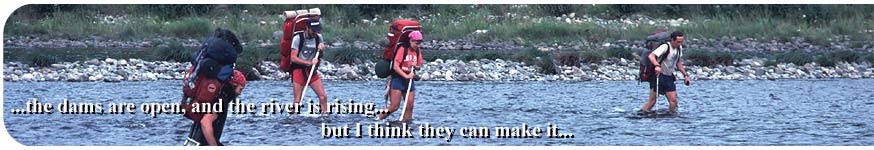
" The dams are open, and the river is rising…..................but
I think they can make it." Well, the clock showed almost
nine already, and we still had just under four miles to get to the
Kennebec! The adrenalin began to flow as we departed from the camp
and rushed down the trail. I was in such a hurry that I seemed to
have to pull the others along as they struggled to keep up with
my blistering pace. I did not want to cross alone.
Along the way I began searching for a pole to brace myself against
the current and give me extra stability during the crossing. I selected
a nice seven or eight feet long tree limb, actually the whole trunk
of a small straight pine tree, and began breaking off the extraneous
limbs in an effort to produce the perfect pole to assist me if needed.
I worked on the tree as I continued to hike toward the river. Some
of the others followed my lead and selected their own poles. Eventually
we rounded a bend to the left and the river came into view. Wow!
We have to cross that? This is a real river - with no bridge! Wilderness
and adventure are what Maine is all about. I was psyched, and ready
to cross. As soon as I reached the riverbank, I sat down and took
off my boots, and put on my spare pair of footware that I carried
just for this occasion. Once the boots were switched, I decided
that where I was standing was not really the place to cross, and
moved upstream a hundred yards or so to the area where three gravel
bars could be seen. I remembered hearing somewhere that the shallowest
crossing was in the area where the three sandbars are located. If
you could not see three sandbars, DO NOT CROSS! The Jerome Brook
Lean-to register had included a map at the back of the book that
confirmed this . A
drawing was provided to show just where hikers could safely
ford. The others followed me, almost cheering me on to be the first
to test the waters for them. The river was 150 - 200 yards wide
and the entire bottom was covered with softball sized and larger
rocks that were rounded and slick after years of smoothing erosion
from water-flow over them. I stepped in and held my pole so the
end was lodged in the stones downstream and then took a few steps
as the cold water rushed around my calf muscles. I moved the pole
forward for the next set of steps and continued this process with
what seemed to be no problem. I reached the first gravelbar and
turned around to watch the others as they began their crossing.
I set out for the second gravelbar and the water began to get deeper.
At times the water was rushing past with such force that without
the pole, I surely would have gone down. With a full pack, the results
could definitely be disastrous. I began the crossing by unlatching
my waist strap, thinking that if I did fall in I could get out of
my pack a lot easier. Suddenly my foot slipped off one of the submerged
rocks and I almost fell to my knees. The water rushed around me,
but with the pole that I had lodged downstream and the force of
the current behind me, I immediately popped back up. I would have
been a "goner" had it not been for the pole. Behind me
I heard Nick shout "Go back in! I gotta get a picture."
I just laughed and continued on to the other side. Upon reaching
the safety of the other bank I dropped my pack, extracted my camera
from its pouch and turned to record the group during this historic
event. Nick was traveling with his camera in his hands! I could
see the water rise around the thighs of the hikers in the deeper
sections. I did not notice the amount of time that it took to cross,
but it was the most exciting event on the trail so far. Once on
the other side, "the Maximus" knelt down and kissed the
ground. He was so happy to have made it across.
I replaced my soaked boots with the dry ones and walked up the stony
bank to highway US 201 just beyond. The trail followed the road
for a short distance then turned left onto another side road which
led to the town of Caratunk just a quarter mile up the road. I stole
a couple of green apples from a tree just by the side of the road
and munched the small, tart fruit down. Not quite ripe yet. At the
post office, I received my old boots, the ones I had started with.
Mom had them resoled and now they were back to finish the trip.
I also received some slide film, my gaters ((knee high covers for
my lower legs for prevention of debrees from getting into my boots).
Those major articles plus a load of goodies to munch on all managed
to arrive on time. They were only sent three days ago - via airmail.
I cannot remember any longer what I did with the boots I had been
wearing, or the other shoes I had just christened in the Kennebec,
but I may have boxed them up wet from the river crossing, and sent
them back to Illinois.
Suddenly we saw Lan walking up the street and were surprised. She
had not crossed the river with us, where did she come from? She
relayed the story of how she had attempted to cross the river yesterday,
had fallen in, gotten soaked, and was hauled to Monson to dry out
and recouperate. Mr. Shaw had driven her back this morning to resume
her journey once again. There was a long roadwalk out of Caratunk,
the relocation taking the trail off of the roads was not quite finished
yet, even though the guide and maps showed the trail in the new
location. I enjoyed the country road none-the-less as it led us
past the west shore of Pleasant Pond and some cottages that were
located there. The trail followed a gravel road leading to the right,
off of the main road, which had become a gravel road itself. This
side road brought us right to Pleasant Pond Shelter situated directly
beside the road. As a matter of fact, the road ran directly in front
of the shelter. Pleasant Pond could not be seen from the shelter,
but was within a few hundred yards. We followed a path down to the
shore and explored the area. Someone had parked a car nearby, so
imagining the possibilities presented by the vehicle, we left a
note on the windshield asking if they could take someone to town,
but later when the owner came by, he said he could not oblige us.
Later
that evening we entertained ourselves at the pond by watching the
waves. The wind produced nice waves as it blew directly toward us.
We threw a branch into the pond and each person predicted where
the floating branch would wash up on shore. We also watched a water
bug in a struggle for survival as it ran from the shore to the water
and was pushed back again by the waves, only to try once again,
over and over again.
Ron and Cathy, Nick, Max and I stayed at the shelter that night,
but Lan was in a hurry to finish her trip and decided to push on
for a few more miles that afternoon. Less than nine miles today.
We are turning into softies.
Gonzo!
Appalachian Trail Journals ©1983
|